NL
NLHiking from the Villa
To Santa Maria della Versa
(round trip)
Description
This is a circular walk of approx. 2 hrs. The level of difficulty is determined by the part that bridge a height difference of about 70 meters, on the way up 1x and back 2x. In wet weather, this walk can only be walked on sturdy boots, because the clay soil between the vineyards is then difficult to pass. The alternative is to continue to follow the asphalt roads as much as possible.
1. To the statue of the Madonna
You start at the Villa and walk up to the main road, turn left and immediately right again into the gravel road between the vineyards, until after 5 minutes you reach a bridge over the Versiggia. Just before the bridge, take the path on the right until you reach the asphalt road which goes to St Maria. Turn right and walk for a few minutes until we reach the statue of the Madonna. To the left and right of the road are the vineyards of Tenimento Torti Castelrotto, with signs indicating which grape variety has been planted.
2. Climb to the chapel
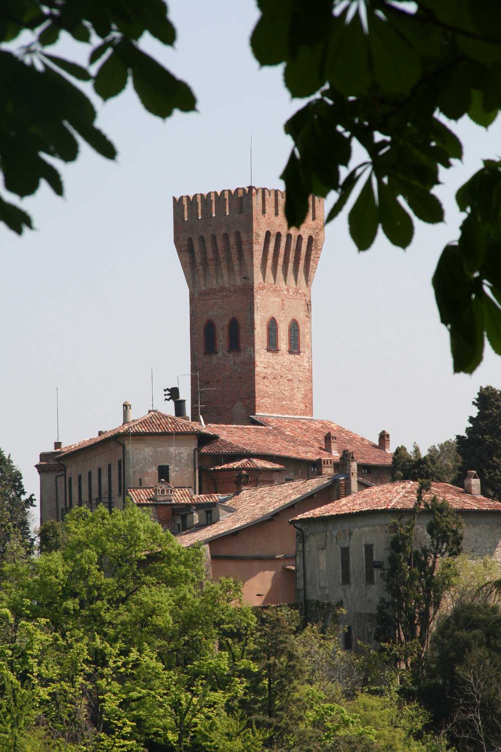
Walk back (we only wanted to see the statue) until the same point where we reached the asphalt road previously. Turn right into the dirt road between the vineyards (opposite the electricity pole on the left). This is the only real climb on the way up, which brings us in about 20 minutes at the top of the hill and a pink chapel.
3. Through Villanova
At the chapel turn left on the asphalt road and walk for another five minutes until a T-junction with a blue sign “Carichetta/Poggio”. You leave here the asphalt roads and continue straight ahead into the vineyards. Descending you pass some farm barns to finally reach the village streets of the hamlet of Villanova. You follow the asphalt road to the right, go along with the bend, then straight ahead and a bit further with the bend to the left.
4. Santa Maria della Versa
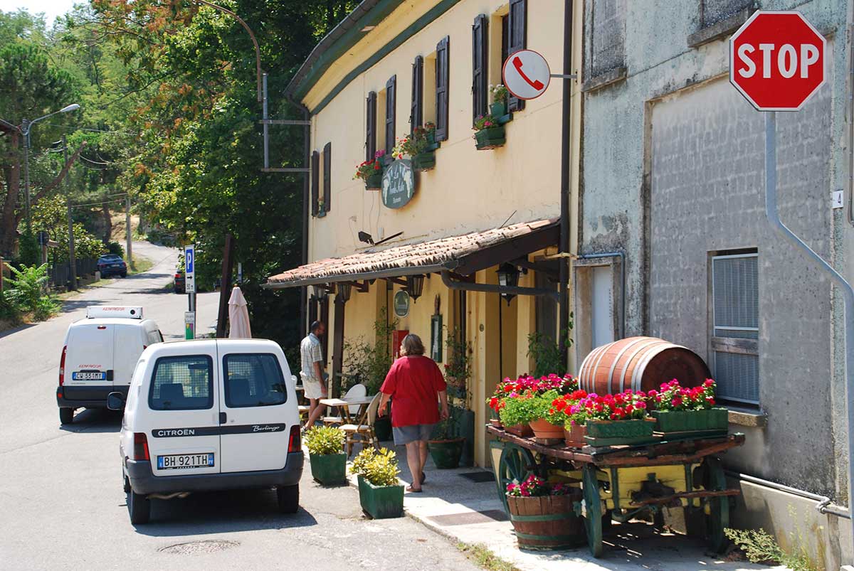
Now you have to watch out because immediately after the white street sign “Palazzo” we go back into the vineyards, to the right. Here we walk almost straight down and after five minutes we reach the village, where you always end up at the main street when you turn left or right, walking down. For a nice cup of coffee with or without a sandwich in a cozy atmosphere, we recommend Café Smile. Furthermore, there are plenty of shops (NB: as everywhere in Italy almost every shop is closed from about 12.30-16 hrs!), a bank, a post office, and every Saturday morning there is a small market. During the summer months of June-August every Thursday evening there is a small evening market in the village.
5. The way back
The way back goes via a slightly different route. You leave the village from the central square via the Via 25 Aprile (past the post office), continue on Via Garibaldi and Via Cavallari to turn right into Via Canova. Follow this road, incl. two right-angled curves, first to the left and then to the right. You pass a few houses and walk straight into the vineyards. Continuing straight ahead, you reach again the road to “Carichetta/Poggio” (see 3). Turn right and go a little bit along the same road as you came until just before the first dilapidated building on the right. We turn right into the vineyards, via the gravel road. You follow this all the way straight down, until you reach the asphalt road, where you take a left turn until you finally reach the bridge over the Versiggia mentioned above. We cross the bridge and climb up via the famous gravel road to your starting point.
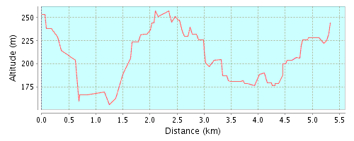
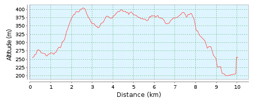
height profile
Height difference:
113 Meter (height of 192 Meter tot 305 Meter)
Total ascend: 245 Meter
Total descend: 245 Meter
From the Villa to Agriturismo Bagarellum
(one way)
Description
This is a walk of about 1 hour, and about 45 minutes back. The level of difficulty is determined by the ascend of about 200 meters, with the strongest climbs on the way to Casone. The walk can be combined with a lunch or dinner at Agriturismo Bagarellum (only open on Saturday evening and Sunday afternoon, and by appointment).
To Casone
At the top of the road at the villa, turn right and continue until you reach the church of Casella. You leave the church on your left and you climb up. Once on the road follow to the left. The road then comes together again with the SP45. Follow that road to the right. You pass a road construction company ("Cerutti"). At the gate of the main entrance, choose the small road to the right. You pass the yard of a farm. The asphalt road goes over into a dirt road. Go straight ahead. After a few hundred meters you walk back on the asphalt and the climb to the frazione Casone begins.
To Bagarello
Keep following this asphalt road until you go to the left with the road. You pass Ca 'Budha. Keep following the asphalt road that goes through reasonably flat first, but then goes down again and finally rises again. The road finally ends at the wider access road to the frazione Bagarello. Here you turn sharply to the left until Bagarello has arrived. Follow the signs "Agriturismo Bagarellum".
Height profile
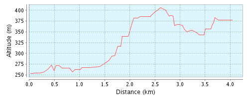
height difference:
153 Meter (height from 253 Meter tot 406 Meter)
Total ascend: 190 Meter
Total descend: 73 Meter
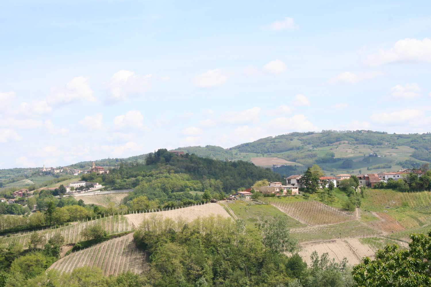
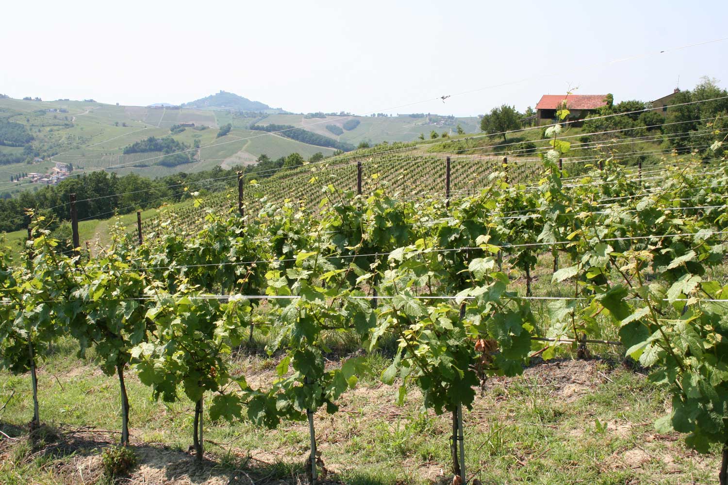
From the Villa to Ca'Bosco and Casone
(round trip)
Description
(ca. 6km, 1.30 à 1.45 hrs, jeight difference appr. 200 meter. There is no bar or restaurant on the way: bring your own food/drinks!)
1. Through the vineyards
You start at the gate of the villa. You turn right and walk between the houses of Roberto Vercesi, then leave the asphalt road and continue on the gravel road that leads to the Scuropasso stream down in the valley. At the second passage between the vineyards on your left, turn left and follow this path until you reach a wide strip of land between the vineyards. Here you turn right and follow this strip slightly downwards until you can climb up along a forest edge/scrub on your right and a vineyard on the left. You pass a small open field with a abandoned cart. You follow the path further up and turn right at the big oak tree in front of you. The path runs from there down around a vineyard (again). As you walk down you will see at your left a turret. This turret is along the provincial road from Casella to Michelazza. You climb straight up through the vineyard to that turret.
2. Michelazza
Follow the road for about 100 meters down to the hairpin bend. In this bend you will see on the right a path that goes down alongside a fence. You turn into this path and keep that fence on your left. The path leads to the yard of a house in Michelazza. You continue on the paved street opposite of you. Approximately 70 meters further, in front of the house with number 5, you can go through a (grass) slope between two houses and then reach again the provincial road. Here you turn right. Shortly thereafter, after the last house of Michelazza (with a large terrace/balcony), you turn right again into a path that runs down a small stream (if there is enough water, of course). You pass a bamboo grove. Below you cross the provincial road again.
3. To Ca'Bosco
You are now almost at the lowest point of the hike. A little to the left and opposite of you there is an road that goes to Ca 'Bosco. You can already see this white house in the distance. Follow this paved road, which first goes slightly downwards but then continues to rise. Almost at the end of that road, close to Ca 'Bosco you leave the asphalt road and turn left, along the edge of the forest, onto the path that goes up steeply. You will probably have been greeted and barked by all dogs (about seven) of Ca 'Bosco. Remember, barking dogs do not bite! You follow this steep path, which has been worn out by heavy rainfall. Above, this path continues in a semicircle to the left between two vineyards. You continue to follow the path up until you reach the tarmac road from Francia to Casone.
4. To Ca'Budda
You turn right and climb up via this fairly steep road. After just over 100 meters, turn right into a sandy path that leads into the forest above Ca 'Bosco. You continue to follow this (sometimes muddy) path until you reach a site a vineyard. Here you keep right/straight. The path continues for a dozen meters through the forest. Then in the open field the path turns to the left in a semicircle, and upwards, in the direction of two free standing trees that stand on the corner of a vineyard. Once there you can see the buildings and fences of the wine company San Michele ai Pianioni. Follow the edge of the vineyard (on your left), which after about 50 meters turns to the left. You keep the shed and the house on your right. A little further to the turn right (keep concrete wall on the right) and go up the concrete stairs that lead up to the gate. At this gate, turn right and follow the fence until you reach the driveway of the house. You then follow the driveway up to the asphalt road.
5. Back to Spagna
You are now at the highest point of the walk. Here you have the option to continue walking to Bagarello (20 minutes) and possibly to Crocetta (40 minutes). You continue this walk by turning left and following the asphalt road downwards. You walk this road until you arrive at the provincial road Francia-Crocetta. The building materials company Ceruti is on your left. You turn left towards Francia. In Francia you can continue to follow the provincial road or take the small cross-road to the left that leads you through the frazione. At the church you will return to the provincial road. At the T-junction you continue straight ahead towards Castana. A little more than a hundred meters past the junction you will see the sign Spagna and the villa.
Height profile
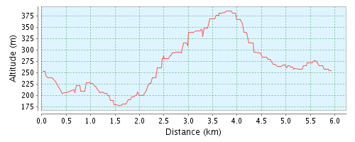
Height difference:
209 Meter (height from 177 Meter to 386 Meter)
Total ascend: 247 Meter
Total descend: 247 Meter
From the Villa to Cigognola
(one way)
Beschrijving
Duration of the walk: approx. 2 to 2.5 hrs. The road follows largely paved roads. On the way in Lirio and Pietra De'Giorgi and at the end in Cigognola one can eat or drink in the local bar.
1. To the Scuropasso valley
The walk starts at the gate of the villa. You turn left to the main road and then left again. You pass the frazione Tromba and Casa Filippine. After the pink house (on the right) and slightly further on a gray house on the left, turn left into the vineyards (at the electricity pole with a white sign with the following text: "Divieto la discarica"). Follow the dirt path. After a few hundred meters you walk between the houses of a small nameless hamlet. You arrive at a paved road and follow that road downwards. You pass the bridge over the Scuropasso. PLEASE NOTE: You are now on the provincial road to Zavatarello.
2. To Lirio
After the bridge you walk 20 meters to the left and turn right just before restaurant "Amici Miei". You follow the paved road that climbs to Lirio. You pass the cemetery (on your left) of Lirio. Follow the road to the village. When you arrive at the village, you continue straight on (the provincial road bends to the right) and you enter Via del Pozzo. Follow this road until you arrive at the village square. Here you can, as a small detour, climb a bit further up (Via Roma) to view the parish church of Lirio.
3. To Boffalora
From the village square you walk a short distance towards Montalto Pavese. Twenty meters further on, turn right onto Via 24 Maggio. At the junction with the chapel with the Madonna, keep left. The road climbs upwards. At the T-junction (with a branch to the right) you continue straight ahead. At the next T-junction (branch to the left) you also keep going straight up. Almost at the top, at the small group of houses (Località Costa Grossa) you still walk straight ahead, although there is a sign that the entrance is only intended for "residenti". You then keep to the right at the junction and follow the paved road. You keep following this road and after a few kilometers you pass the hamlet of Boffalora.
4. To Pietra De'Giorgi
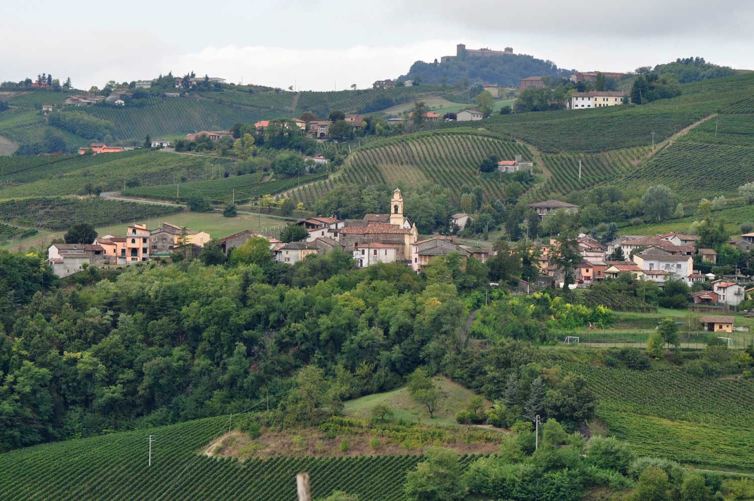
At the junction above Boffalora you continue straight ahead. Follow the road until you reach the road from Scorzoletta (in the valley below you) to Pietra De'Giorgi (there is a traffic "Stop" sign here). You follow this road to the left (you actually walk straight ahead). A few hundred meters further at the T-junction you keep left. After about a further 300 meters you take the path downwards to your right. Follow this path until you arrive in Pietra De'Giorgi. You walk past the castle (top right) and you arrive at a small square with a bar.
5. To Cigognola
Walk straight ahead from the square, ignore the road on the left that goes downwards, and where the street road bends sharply to the right, walk straight up on Via G. Porri. At the top of the hill, leave the paved road and continue along the unpaved path on the right between the slope and the vineyard. You walk down until you reach the street on the other side of the hill again. Here you turn left and continue to follow the road to Cigognola. You continue to follow the road until you reach the village square. From the square you can follow a paved footpath to the top: you will arrive at the Belvédère with a war memorial. From this point you have a magnificent view over the Po Valley. In clear weather you can see the Alps with the Monte Rosa massif and even Milan. Opposite the town hall on the village square there is a bar / restaurant. NB: The castle of Cigognola is in private possession and can not be visited.
Height profile
Height difference:
239 Meter (Height from 151 Meter tot 390 Meter)
Total ascend: 274 Meter
Total descend: 237 Meter
Golferenzo
(circular walk)
Description
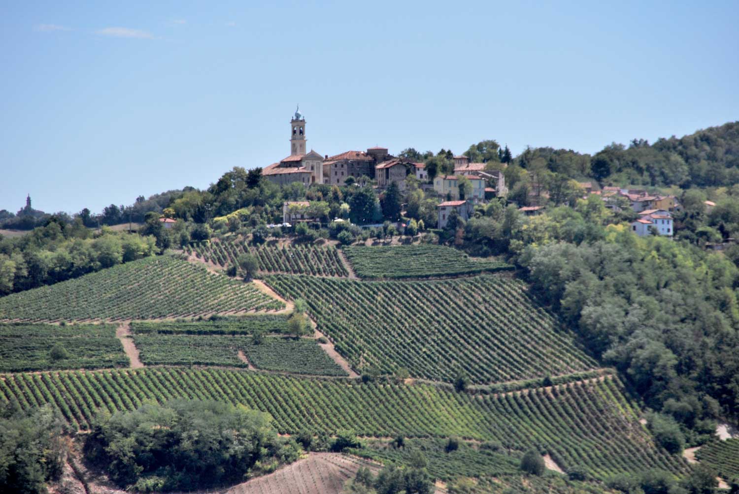
Unlike the previous walks, it does not start at the Villa but in Golferenzo, a small village located in the hills behind Santa Maria della Versa, a 15 minutes drive from the villa. If you go to Santa Maria via Crocetta (the center of Montecalvo Versiggia), you will automatically see the exit sign to Golferenzo (right).
1. Golferenzo
The walk is partly sign posted by red/white direction pointers. The walk starts for the town hall of Golferenzo. You park your car in one of the parking spaces. You walk to the east (keep the town hall on your left) and after 170m you will see on the intersection an information board with the "Sentieri di Golferenzo". We follow the route of walk 32A. From the junction you leave the main road and turn into Via Brevio. Before you, you see a small chapel. You take the road to the left of the chapel. You continue on this slowly rising road also when it changes from a paved road into a gravel road.
2. Ca' Scagliosi
The road continues to climb and in clear weather you have beautiful views on the valley of the little river Versa . In clear weather you can see the Monte Rosa massif 150 km to the north. You continue to follow the path past an "agricultural outpost" of the "University of the Islands" (?). Eventually, in Ca 'Scagliosi you will arrive again on the paved road. Here you turn right and follow the paved road.
3. La Ca'
You follow the road downwards. On the right and before you, you will see a water basin. At the junction, head towards Golferenzo and La Ca ', and the water basin. At the edge of the basin you will pass a second information board with the "Sentieri di Golferenzo". 300 meters after the water basin, turn left to la Ca '. The paved road passes a farm and tutns into a gravel path that ends on another asphalted road. Here you turn left to a group of houses 150 meters away. This is Ca 'Guastone. At the junction, turn right to a farm a little further to your right: Ca 'Colombara.
4. from Ca' Colombara to Golferenzo
You walk around the farm (you keep the buildings on your right) until you reach the edge of the vineyard. Slightly to the right you can walk between the vineyards, to the left and down. You can already see Golferenzo in front of you. You continue straight ahead (the path crosses a ditch) and you follow the path until it connects with the road to Golferenzo (approx. 800m after Ca 'Colombara). You walk towards Golferenzo. A little further there is a third information board with a picnic table. The main road turns to the left, but you walk straight into the street to the square in front of the town hall of Golferenzo.
Height profile
Height difference:
183 Meter (Height from 404 Meter to 587 Meter)
Total ascend: 179 Meter
Total descend: 179 Meter
To Lirio and terug
(round trip)
Description
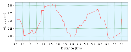
This is a circular walk of about 2 hours and 5 km. In wet weather, this walk can only be done with sturdy boots, because the clay soil between the vineyards is very difficult to walk on, especially down at the Scuropasso creek.
1. Down, into the valley of the Scuropasso
You start at the Villa and walk down to the houses of the other inhabitants of Spagna. The tarmac road turns into a gravel path. Continue on this path,, until after a minute or ten you reach a bridge over the the Scuropasso stream. Turn right (direction Pavia/Broni) on the main provincial road until you see the restaurant Amici Miei after about ten minutes (appr. 600 meters).
2. Up to Lirio
Immediately after Amici Miei, turn left into an asphalt road. This road climbs steeply up to the cemetery of Lirio. We walk further up the asphalt road to the village of Lirio, which although small is one of the oldest hamlets in the area. It is already mentioned in a deed by Frederik Barbarossa (12th century). In Lirio there is a small characteristic bar and osteria.
3. Leaving Lirio and back to the valley
On the square with the osteria turn left and enter the Via Roma. Keep right and stay on Via Roma. At the T-junction with a crucifix on the foot of the tree, turn right. Follow this small road until the fork in the road where you keep left. You descend until you reach Palazzina on the main road through the Valle Scuropasso. Turn right and follow this road for about 500 meters. Meanwhile you pass Agriturismo Carolina and a public weighbridge/square on the right. Take the small road on the left (with a guardrail on the left) and after a few minutes we arrive at a stone arch bridge over the Scuropasso. Immediately after the bridge go left,. You now walk on a clay road with the Scuropasso on the left and a vineyard on the right. We continue until the road goes to the right. We now climb up until we reach an asphalt road (this can be a little puzzling, but if you keep walking up, you can not miss the road). On the asphalt road we turn left and after a short time we reach the road that goes up to Spagna.
4. Through Michelazza back to Spagna
We do not take this road, but we cross it, go a little bit to the left and immediately turn right into a path crossing the meadow, which ends again on the asphalt road. Follow the road but as soon as you can, turn left and walk through Michelazza until you reach a large white house, on the right. We walk more or less in the yard of this house, but go straight ahead and and take the path upwards along a fence (at your right hand). Eventually you get back on the road to Spagna. Follow the road until the chapel/turret and from there you can cross the vineyards again to return to the villa.
Height profile
Height difference:
101 Meter (Height of 156 Meter to 257 Meter)
Walking the dog
(round trip)
Description
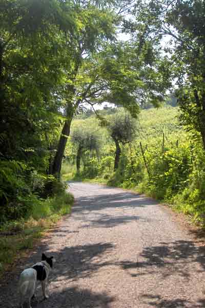
This is a nice short round trip to walk the dog. You start at the fence of the villa. Go left and up to the main road. Turn left and after10 meters immediately right again on the gravel road that goes to the Versiggia stream down in the valley. Just before the small bridge over the Versiggia you take the path to the right. After about 150 meters you will reach the asphalt road. Follow this road to the right and keep following it (always on the right) until you are back at frazione Spagna. In the meantime you will pass the wine company Torti, and the frazione Frenzo, Francia and Casella.
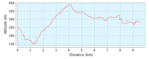
To Crocetta and further
(round trip)
Description
This is a circular walk of 10.5 km which stays entirely within the boundaries of the municipality of Montecalvo Versiggia. There are a number of considerable differences in height to overcome (320 meters). For the most part, the route follows paved roads. On the way there are no cafes, but in the frazione Crocetta you pass restaurant la Verde Sosta, recommended for a good lunch!
1. To Casone
You go up from the villa to the road and turn right towards Casella. At the church, keep right. You walk through the frazione Francia until you have arrived at the provincial road again. You pass the road building company Cerutti and at the gate of this company you choose the small road on the right. You continue to follow this road. You pass a farmyard where the tarmac turns into gravel. After about 300 meters you walk again on tarmac. Here begins the climb up to the frazione Casone. At the end of the climb the road turns to the left. You pass Casone after which the road descends and then climbs again
2. to Crocetta
At the end of the 2nd climb, our road joins the road to the frazione Bagarello, but you continue in the opposite direction, straight ahead. Follow this road until the frazione Cerchiara meets the provincial road to Rocca de'Giorgi. You do not go to this village but keep left and follow this provincial road to Spinola and beyond. After approx. 800 meters at the T-junction, turn left towards Stradella. NB. Caution is required here: you walk here on a fairly busy provincial road! After about 1.3 km you will reach a viewpoint with benches for a short break. If you want to, you can also take a narrow path downwards for a quick look at the chapel of the Madonna dell'Uva. Continue your way along the provincial road until you reach the frazione Crocetta and there you find the restaurant La Verde Sosta.
3. Back to Spagna
You leave the provincial road in Crocetta and continue straight ahead past the town hall towards Broni and a little further towards Lanzone. Follow the small road and after approx. 1 km turn right at the T-junction and walk through the frazione Poggio. You keep going straight ahead and at the end of the frazione the road descends quite steeply. About 100 meters after the last house of Poggio you leave the road and follow the path between the vineyards that runs down diagonally to the left. This descending path ends on an asphalt road that you follow to the right until the chapel at the bend in the road. You leave the road and follow the gravel path that starts to the right of the chapel. This path ends on an asphalt road. Cross this road. On the other side you follow the path to the right. After about 250 meters you go left and up on the gravel road. At the end of this road you’re almost back at the villa
Height profile
Height difference:
204m (Total ascend 317m, total descend 321m)
City walk Pavia
(one way)
Description
This city walk of approx. 2.5 km takes you to the main sights of Pavia. Keep in mind that the churches to be visited (and many shops) have an afternoon closing (they usually open again at 16.00 hrs.). The center of Pavia is partly a pedestrian area and has limited access for cars. Paid parking applies everywhere.
1. San Pietro in Ciel d’Oro
You can park your car in the Buco car park, accessible via the Viale Nazaria Sauro. You leave the parking lot through the gate that is opposite the parking meter. After about ten meters you arrive at the Piazza San Pietro in Ciel d'Oro. You walk past the offices of the carabinieri to the Basilica. In this 12th century Romanesque church, the bodies of St. Augustine (354-430 AD) and the Roman philosopher Boetius (480-525 AD) are buried. The tomb of Augustine is on the main altar, and that of Boetius in the crypt of the church. The name of the church is derived from the "golden" mosaic of Saint Peter above the main altar.
2. Castello Visconteo
After leaving the church, turn left and walk past the Augustinian monastery to Viale Giacomo Matteotti. You cross the road halfway to the pedestrian area between the two carriageways. Walk to the left to the end of the street until you reach the Boetius monument. According to tradition, he was executed on this spot by order of the East Gothic king Theodoric. On the left you will see it park and gardens of the Castello Visconteo. This castle houses the Musei Civici of Pavia, including the archaeological museum and the Pinacoteca Malaspina. Opening hours:
Mon-Fri: 2.30 pm to 6 pm
Sat-Sun: 11 am to 7 pm
3. University
From the Boetius monument you walk into the Strada Nuova past the Teatro Fraschini from 1773. It is a typical Italian theater (like the Scala in Milan) and if you have the chance to visit a performance, this is definitely worth it. Past Piazza Italia, with the provincial government office, you will see the buildings of the University of Pavia on your left. This university is one of the oldest in Europe, founded in 1361 AD. Halfway through the somewhat strict and long facade of this building you will see the entrance gate, flanked by two wall medallions. You walk inside and to the left and right you can already see two of the many courtyards of this university building. One of the most famous scientists the university has produced is Alessandro Volta (1745-1827), the inventor of the battery. A statue of him is in one of the courtyards. Also Albert Einstein studied here for a while. From the main entrance one courtyard to the left, then two to the right and another to the left and you will find in the latter courtyard a café with a terrace that is crowded with students. The university museum houses a small but interesting collection in the field of mineralogy, pathological anatomy and musicology. Opening hours:
Mon: 14:00-17:00
Wed: 9:00-12:00
Fri: 9:00-13:00
4. Piazza Leonardo da Vinci
You go back to the main entrance of the university, but do not walk back to Strada Nuova, instead to the opposite direction to Piazza Leonardo da Vinci. You will pass the university auditorium on your right. On the square you can view the crypt of the original St. Eusebio church that once stood here. Halfway and at the end of the square you will see 3 of the remaining 5 medieval civil towers of Pavia that are still standing. In the Middle Ages, by the way, there were dozens more. Every rich family built one!
5. Piazza Vittoria
Leave Piazza Loeonardo da Vinci via Via Giuseppe Galliano and continue until Corso Guiseppe Mazzini. Here you turn right. You walk on and cross the Strada Nuova until you reach Piazza Vittoria. This is the heart of Pavia. There are many terraces on this square where you can enjoy a delicious aperitif. On the south side of this square is the Palazzo Broletto, the town hall of Pavia. Below the northern part of the square is an underground market / shopping mall.
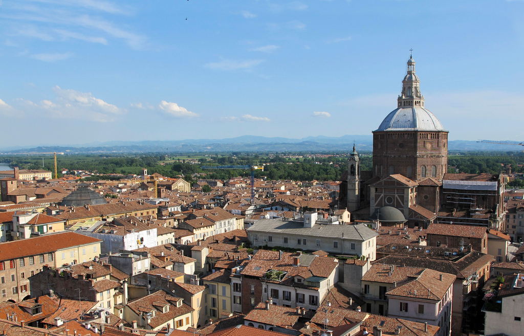
6. Duomo
Standing in front of Palazzo Broletto, turn right into Via Giovanni Antonio Omodea and continue until you reach Piazza Duomo. The Duomo has recently been restored and has one of the largest domes in Italy. To the left of the Duomo you can see the remains of one of the civil towers that once stood here and collapsed in 1989, causing the death of 4 pedestrians. A plaque commemorates these victims.
7. San Michele
You walk past the equestrian statue (it is unknown who this is) and you turn left and walk back via Via Cardinal Augustino and Piazza Cavagneria to Strada Nuova. Here you turn right and then left into Corso Guiseppe Garibaldi. At the second side street you turn right into Via San Michele. On the square that follows you will see on your left the oldest church of Pavia, the San Michele. During the period that Pavia was the capital of the Lombard kingdom (568 – 774 aC), the kings were crowned in this church with the Iron Crown.
8. Ponte Coperto
As you leave the church, turn left and continue along Via Paolo Diacono to the bank of the Ticino River that flows through Pavia. You turn right and you can see the covered bridge in front of you. This is a modern replica of the old bridge that was destroyed in World War II. From the new bridge you can still see the pillars of the old one. At the end of the bridge to the left you see the statue of a laundress, erected here as a tribute to the many women who in the past did laundry in the river for the people of Pavia.